Zambia Flag
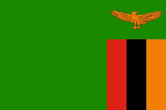
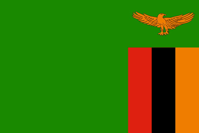
Zambia's flag is a symbol of the country's independence, history, and aspirations. The flag of Zambia was designed in 1964, shortly after the country gained independence from British colonial rule, and it depicts the country's unique cultural, historical, and geographical characteristics.
The green color depicts the country's lush vegetation, the red color signifies the struggle for independence, and the black color represents the Zambian people. The orange stripe represents the country's natural resources and mineral richness, while the eagle in flight depicts the power of the people to rise above the nation's challenges. In 1996, the flag was significantly altered to make the green color brighter and lighter, and to align the eagle with the design of the national coat of arms.
Zambia flag downloads
- completely free for commercial and non-commercial use (public domain)
- based on vector file from Wikipedia Commons
- PNG or WebP format (lossless compression)
- Right click on the links (save link as)
| Width | Height | PNG | WebP |
|---|---|---|---|
| 20px | 13px | ~0.1 KB | ~0.1 KB |
| 40px | 27px | ~0.4 KB | ~0.1 KB |
| 80px | 53px | ~0.7 KB | ~0.1 KB |
| 160px | 107px | ~2.6 KB | ~0.6 KB |
| Width | Height | PNG | WebP |
|---|---|---|---|
| 16px | 12px | ~0.1 KB | ~0.1 KB |
| 40px | 30px | ~0.4 KB | ~0.1 KB |
| 80px | 60px | ~0.8 KB | ~0.1 KB |
| 128px | 96px | ~2.5 KB | ~0.6 KB |
- completely free for commercial and non-commercial use (public domain)
- based on vector file from Wikipedia Commons
- PNG, WebP (lossless compression) or JPEG format (100% quality)
- Right click on the links (save link as)
| Width | Height | PNG | WebP | JPEG |
|---|---|---|---|---|
| 2560px | 1707px | ~2.6 KB | ~0.6 KB | ~34.9 KB |
| 1280px | 853px | ~0.7 KB | ~0.1 KB | ~13.0 KB |
| 640px | 427px | ~0.4 KB | ~0.1 KB | ~5.6 KB |
| 320px | 213px | ~0.2 KB | ~0.1 KB | ~2.8 KB |
| 160px | 107px | ~0.1 KB | ~0.1 KB | ~1.5 KB |
| 80px | 53px | ~0.1 KB | ~0.1 KB | ~0.9 KB |
| 40px | 27px | ~0.1 KB | ~0.1 KB | ~0.6 KB |
| 20px | 13px | ~0.1 KB | ~0.1 KB | ~0.4 KB |
- completely free for commercial and non-commercial use (public domain)
- based on vector file from Wikipedia Commons
- SVG, PDF (Adobe Acrobat), AI (Adobe Ilustrator) or EPS format
- Right click on the links (save link as)
| Format | SVG | AI | EPS | |
|---|---|---|---|---|
| Vector download | ~0.3 KB | ~12.5 KB | ~29.7 KB | ~1533.8 KB |
Country information
Zambia is a country located in southern Africa, bordered by Angola to the west, the Democratic Republic of the Congo to the north, Tanzania to the north-east, Malawi to the east, Mozambique to the south-east, Zimbabwe, Botswana, and Namibia to the south, and the Republic of the Congo to the west. It is a culturally diverse country with a mix of different ethnicities and religions.
The history of Zambia dates back to ancient times, with the first human settlements dating back to at least 1000 BC. The country has a long and complex history, with a mix of Bantu, European, and other influences. Zambia gained independence from Britain in 1964, and has since gone through a number of political and economic challenges.
Today, Zambia is a lower-middle-income country with a large and diversified economy. The country is known for its production of copper, which accounts for a large portion of its GDP, as well as for its agricultural and manufacturing industries. Zambia has a tropical climate, with hot and humid weather year-round. The official language of Zambia is English.
| Independent | Yes |
| Country codes | ZM, ZMB (ISO 3166-1) |
| Official name | Republic of Zambia |
| Official languages | English and Icibemba (Bemba) |
| Religion | Christianity |
| Capital city | Lusaka |
| Continent | Africa |
| Time zone | UTC+2 (CAT) |
| Member of | United Nations |
| Commonwealth of Nations | |
| African Union | |
| Southern African Development Community | |
| Population | 19,719,426 (2023) |
| Population density | 25 per Km2 (64 people per mi2) |
| Urban Population | 45.3 % of the population is urban (8,336,381 people in 2020) |
| Migrants (net) | -8,000 |
| Median age | 17.6 years |
| Total area | The total land area is 743,390 Km2 (287,024 sq. miles) |
| Highest point | Mafinga Central (2 329 m, 7 641 ft) |
| Lowest point | Zambezi (329 m, 1 079 ft) |
| GDP per capita | $ 1,137 (World Bank, 2021) |
| Currency | Zambian kwacha (ZK, ZMW) |
| Calling code | +260 |
| Internet TLD | .zm (click here to find and register domain name) |
| Country Wikipedia Page | Zambia Wikipedia Page |
Main Cities by Population in Zambia
| # | CITY NAME | POPULATION |
|---|---|---|
| 1 | Lusaka | 1,267,440 |
| 2 | Kitwe | 400,914 |
| 3 | Ndola | 394,518 |
| 4 | Kabwe | 188,979 |
| 5 | Chingola | 148,564 |
| 6 | Mufulira | 120,500 |
| 7 | Luanshya | 113,365 |
| 8 | Livingstone | 109,203 |
| 9 | Kasama | 91,056 |
| 10 | Chipata | 85,963 |
| 11 | Kalulushi | 66,575 |
| 12 | Mazabuka | 64,006 |
| 13 | Chililabombwe | 57,328 |
| 14 | Mongu | 52,534 |
| 15 | Kafue | 47,554 |
| 16 | Choma | 46,746 |
| 17 | Mansa | 42,277 |
| 18 | Kansanshi | 40,705 |
| 19 | Kapiri Mposhi | 37,942 |
| 20 | Monze | 30,257 |
| 21 | Mpika | 28,445 |
| 22 | Nchelenge | 23,693 |
| 23 | Kawambwa | 20,589 |
| 24 | Mbala | 20,570 |
| 25 | Samfya | 20,470 |
| 26 | Sesheke | 20,149 |
| 27 | Petauke | 19,296 |
| 28 | Mumbwa | 19,086 |
| 29 | Siavonga | 18,638 |
