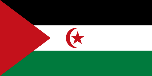
Western Sahara Flag

Western Sahara's flag, formally known as the Sahrawi Arab Democratic Republic, consists of a horizontal tricolor of black, white, and green. The center stripe has a red star and crescent, while the hoist has a red chevron. The flag is predominantly used in areas controlled by the Polisario Front, a political movement fighting for Western Sahara's independence from Morocco, which currently controls the majority of the territory.
The flag's colors represent Pan-Arab and Islamic ideals, with black representing the dark days of occupation, white representing the peace and dignity sought, green representing hope and vitality of the Sahrawi people, red star and crescent representing the Islamic religion, and red chevron representing the blood shed by the Sahrawi people. It was first used on February 27, 1976, and is credited to El Uali Mustafá Sayed, the first President of the Sahrawi Arab Democratic Republic. In June 1991, it was slightly updated.
Western Sahara flag downloads
- completely free for commercial and non-commercial use (public domain)
- based on vector file from Wikipedia Commons
- PNG or WebP format (lossless compression)
- Right click on the links (save link as)
| Width | Height | PNG | WebP |
|---|---|---|---|
| 20px | 10px | ~0.1 KB | ~0.1 KB |
| 40px | 20px | ~0.4 KB | ~0.1 KB |
| 80px | 40px | ~0.7 KB | ~0.1 KB |
| 160px | 80px | ~2.6 KB | ~0.6 KB |
| Width | Height | PNG | WebP |
|---|---|---|---|
| 16px | 12px | ~0.1 KB | ~0.1 KB |
| 40px | 30px | ~0.4 KB | ~0.1 KB |
| 80px | 60px | ~0.8 KB | ~0.1 KB |
| 128px | 96px | ~2.5 KB | ~0.6 KB |
- completely free for commercial and non-commercial use (public domain)
- based on vector file from Wikipedia Commons
- PNG, WebP (lossless compression) or JPEG format (100% quality)
- Right click on the links (save link as)
| Width | Height | PNG | WebP | JPEG |
|---|---|---|---|---|
| 2560px | 1280px | ~2.6 KB | ~0.6 KB | ~34.9 KB |
| 1280px | 640px | ~0.7 KB | ~0.1 KB | ~13.0 KB |
| 640px | 320px | ~0.4 KB | ~0.1 KB | ~5.6 KB |
| 320px | 160px | ~0.2 KB | ~0.1 KB | ~2.8 KB |
| 160px | 80px | ~0.1 KB | ~0.1 KB | ~1.5 KB |
| 80px | 40px | ~0.1 KB | ~0.1 KB | ~0.9 KB |
| 40px | 20px | ~0.1 KB | ~0.1 KB | ~0.6 KB |
| 20px | 10px | ~0.1 KB | ~0.1 KB | ~0.4 KB |
- completely free for commercial and non-commercial use (public domain)
- based on vector file from Wikipedia Commons
- SVG, PDF (Adobe Acrobat), AI (Adobe Ilustrator) or EPS format
- Right click on the links (save link as)
| Format | SVG | AI | EPS | |
|---|---|---|---|---|
| Vector download | ~0.3 KB | ~12.5 KB | ~29.7 KB | ~1533.8 KB |
Country information
Western Sahara is a disputed territory located in North Africa, on the Atlantic coast. It is bordered by Morocco to the north, Algeria to the northeast, and Mauritania to the east and south. Western Sahara has been the subject of a long-standing territorial dispute between Morocco and the Sahrawi Arab Democratic Republic (SADR), a partially recognized state that claims sovereignty over the territory.
The history of Western Sahara dates back to ancient times, with the first human settlements dating back to at least 4000 BC. The territory has a long and complex history, with a mix of Arab, African, and other influences. Western Sahara was a Spanish colony until 1975, when it was partitioned between Morocco and Mauritania. The Sahrawi people, who are the indigenous population of Western Sahara, have been fighting for independence from Morocco since then.
Today, Western Sahara is a largely uninhabited territory, with a small and undeveloped economy. The territory is known for its phosphate deposits, as well as for its fishing and tourism industries. Western Sahara has a desert climate, with hot and dry weather year-round. The official language of Western Sahara is Arabic, and the population is primarily made up of Sahrawi people.
| Independent | No |
| Country codes | EH, ESH (ISO 3166-1) |
| Official name | Sahrawi Arab Democratic Republic |
| Official languages | Arabic |
| Religion | / |
| Capital city | El Aaiún |
| Continent | Africa |
| Time zone | UTC+01:00 |
| Member of | African Union |
| Population | 635,426 (2023) |
| Population density | 2 per Km2 (6 people per mi2) |
| Urban Population | 86.8 % of the population is urban (518,663 people in 2020) |
| Migrants (net) | 5,582 |
| Median age | 28.4 years |
| Total area | The total land area is 266,000 Km2 (102,703 sq. miles) |
| Highest point | / |
| Lowest point | Sebjet Tah (-55 m, -180 ft) |
| GDP per capita | $ / (World Bank, 2021) |
| Currency | Moroccan dirham (د.م., MAD) |
| Calling code | +2125288, +2125289 |
| Internet TLD | .eh (click here to find and register domain name) |
| Country Wikipedia Page | Western Sahara Wikipedia Page |
Main Cities by Population in Western Sahara
| # | CITY NAME | POPULATION |
|---|---|---|
| 1 | Laayoune | 196,331 |
| 2 | Dakhla | 75,000 |
