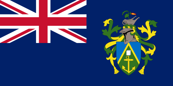
Pitcairn Islands Flag

The Pitcairn Islands coat of arms is an official insignia of the British Overseas Territory of the Pitcairn Islands, given by royal warrant on November 4th, 1969. The coat of arms depicts a shield with a green and blue field. The top half of the shield is blue, with a gold image of the HMS Bounty, which represents the mutiny on the ship in 1789 and the mutineers' subsequent colonization of the islands.
The shield's lower half is green, with a representation of the island, a Pitcairn Island Wheelbarrow, and a representative of the island's flora: the indigenous Pitcairn Island Ivy. The whole is supported by a ship's figurehead of the Bounty, which is topped with a helmet with a wheat sheaf and a Pitcairn Island Reed Warbler. A banner with the island's slogan “Children of the Bounty” adorns the arms.
The coat of arms also appears on the Pitcairn Islands' flag, a Blue Ensign, which was awarded on April 2nd, 1984. This flag, like the coat of arms, is an official emblem of the territory, and it is displayed alongside the Union Jack at all official events and at government buildings across the territory.
Pitcairn Islands flag downloads
- completely free for commercial and non-commercial use (public domain)
- based on vector file from Wikipedia Commons
- PNG or WebP format (lossless compression)
- Right click on the links (save link as)
| Width | Height | PNG | WebP |
|---|---|---|---|
| 20px | 10px | ~0.1 KB | ~0.1 KB |
| 40px | 20px | ~0.4 KB | ~0.1 KB |
| 80px | 40px | ~0.7 KB | ~0.1 KB |
| 160px | 80px | ~2.6 KB | ~0.6 KB |
| Width | Height | PNG | WebP |
|---|---|---|---|
| 16px | 12px | ~0.1 KB | ~0.1 KB |
| 40px | 30px | ~0.4 KB | ~0.1 KB |
| 80px | 60px | ~0.8 KB | ~0.1 KB |
| 128px | 96px | ~2.5 KB | ~0.6 KB |
- completely free for commercial and non-commercial use (public domain)
- based on vector file from Wikipedia Commons
- PNG, WebP (lossless compression) or JPEG format (100% quality)
- Right click on the links (save link as)
| Width | Height | PNG | WebP | JPEG |
|---|---|---|---|---|
| 2560px | 1280px | ~2.6 KB | ~0.6 KB | ~34.9 KB |
| 1280px | 640px | ~0.7 KB | ~0.1 KB | ~13.0 KB |
| 640px | 320px | ~0.4 KB | ~0.1 KB | ~5.6 KB |
| 320px | 160px | ~0.2 KB | ~0.1 KB | ~2.8 KB |
| 160px | 80px | ~0.1 KB | ~0.1 KB | ~1.5 KB |
| 80px | 40px | ~0.1 KB | ~0.1 KB | ~0.9 KB |
| 40px | 20px | ~0.1 KB | ~0.1 KB | ~0.6 KB |
| 20px | 10px | ~0.1 KB | ~0.1 KB | ~0.4 KB |
- completely free for commercial and non-commercial use (public domain)
- based on vector file from Wikipedia Commons
- SVG, PDF (Adobe Acrobat), AI (Adobe Ilustrator) or EPS format
- Right click on the links (save link as)
| Format | SVG | AI | EPS | |
|---|---|---|---|---|
| Vector download | ~0.3 KB | ~12.5 KB | ~29.7 KB | ~1533.8 KB |
Country information
The Pitcairn Islands are a group of four small islands located in the Pacific Ocean, about 5,000 miles east of New Zealand. The islands are a territory of the United Kingdom, and are the smallest British overseas territory in terms of population and land area. The Pitcairn Islands are known for their stunning natural beauty, with a rugged coastline and lush forests.
The history of the Pitcairn Islands dates back to ancient times, with the first human settlements dating back to at least 1000 AD. The islands were first discovered by Europeans in the 18th century, and were later settled by the mutineers of the HMS Bounty and their Tahitian companions. The Pitcairn Islands became a territory of the United Kingdom in 1838, and have been self-governing since 1838.
Today, the Pitcairn Islands are a small and isolated community, with a population of about 50 people. The economy of the islands is largely based on agriculture, fishing, and tourism. The islands have a subtropical climate, with warm and humid weather year-round. The official language of the Pitcairn Islands is English, and the islands have a diverse population with a mix of British, Tahitian, and other ethnicities.
| Independent | Yes |
| Country codes | PN, PCN (ISO 3166-1) |
| Official name | Pitcairn Group of Islands |
| Official languages | Pitkern and English |
| Religion | / |
| Capital city | Adamstown |
| Continent | Oceania |
| Time zone | UTC-08:00 |
| Member of | Pacific Community |
| Population | 47 (2021) |
| Population density | 1/km2 (2.6/sq mi) |
| Urban Population | / |
| Migrants (net) | / |
| Median age | / |
| Total area | The total land area is 47 km2 (18 sq mi) |
| Highest point | Pawala Valley Ridge (347 m, 1 138 ft) |
| Lowest point | South Pacific Ocean |
| GDP per capita | $ / (World Bank, 2021) |
| Currency | New Zealand dollar ($, NZD) |
| Calling code | +64 |
| Internet TLD | .pn (click here to find and register domain name) |
| Country Wikipedia Page | Pitcairn Islands Wikipedia Page |
Main Cities by Population in Pitcairn Islands
| # | CITY NAME | POPULATION |
|---|---|---|
| 1 | / | / |
