Côte d'Ivoire Flag
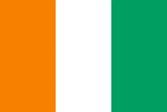
The orange color represents the savannas that dominate the landscape of the country. The white color symbolizes peace, while the green color represents hope and the country's forests. The flag was adopted on December 3, 1959, when Ivory Coast gained independence from France.
It was designed by Houphouët-Boigny, the first president of Ivory Coast, who chose the colors based on their symbolism for the country. The flag has remained unchanged since its adoption, and it is an important national symbol for the people of Ivory Coast.
Côte d'Ivoire flag downloads
- completely free for commercial and non-commercial use (public domain)
- based on vector file from Wikipedia Commons
- PNG or WebP format (lossless compression)
- Right click on the links (save link as)
| Width | Height | PNG | WebP |
|---|---|---|---|
| 20px | 13px | ~0.1 KB | ~0.1 KB |
| 40px | 27px | ~0.4 KB | ~0.1 KB |
| 80px | 53px | ~0.7 KB | ~0.1 KB |
| 160px | 107px | ~2.6 KB | ~0.6 KB |
| Width | Height | PNG | WebP |
|---|---|---|---|
| 16px | 12px | ~0.1 KB | ~0.1 KB |
| 40px | 30px | ~0.4 KB | ~0.1 KB |
| 80px | 60px | ~0.8 KB | ~0.1 KB |
| 128px | 96px | ~2.5 KB | ~0.6 KB |
- completely free for commercial and non-commercial use (public domain)
- based on vector file from Wikipedia Commons
- PNG, WebP (lossless compression) or JPEG format (100% quality)
- Right click on the links (save link as)
| Width | Height | PNG | WebP | JPEG |
|---|---|---|---|---|
| 2560px | 1707px | ~2.6 KB | ~0.6 KB | ~34.9 KB |
| 1280px | 853px | ~0.7 KB | ~0.1 KB | ~13.0 KB |
| 640px | 427px | ~0.4 KB | ~0.1 KB | ~5.6 KB |
| 320px | 213px | ~0.2 KB | ~0.1 KB | ~2.8 KB |
| 160px | 107px | ~0.1 KB | ~0.1 KB | ~1.5 KB |
| 80px | 53px | ~0.1 KB | ~0.1 KB | ~0.9 KB |
| 40px | 27px | ~0.1 KB | ~0.1 KB | ~0.6 KB |
| 20px | 13px | ~0.1 KB | ~0.1 KB | ~0.4 KB |
- completely free for commercial and non-commercial use (public domain)
- based on vector file from Wikipedia Commons
- SVG, PDF (Adobe Acrobat), AI (Adobe Ilustrator) or EPS format
- Right click on the links (save link as)
| Format | SVG | AI | EPS | |
|---|---|---|---|---|
| Vector download | ~0.3 KB | ~12.5 KB | ~29.7 KB | ~1533.8 KB |
Country information
Côte d'Ivoire, also known as Ivory Coast, is a country located in West Africa, bordered by Burkina Faso and Mali to the north, Ghana to the east, Liberia and Guinea to the west, and the Gulf of Guinea to the south. It is home to over 26 million people, making it the 57th most populous country in the world.
Côte d'Ivoire has a diverse and multicultural society, with over 60 indigenous languages spoken throughout the country. French is the official language, reflecting the country's colonial history as a former French colony. The country has a predominantly Muslim population, with a small minority of Christians and other religious groups.
Côte d'Ivoire has a varied and unique landscape, ranging from rainforests to savannas to mountains. The country is known for its beautiful beaches and natural scenery, and it is a popular tourist destination.
Côte d'Ivoire has a strong and diversified economy, with a wide range of industries including agriculture, manufacturing, and mining. It is a major exporter of cocoa, coffee, and oil, and it is also home to a growing technology sector.
Côte d'Ivoire has a presidential system of government and is a democratic republic. It is a member of the United Nations, the African Union, and the Economic Community of West African States, and it has a strong relationship with France, its former colonial power.
| Independent | Yes |
| Country codes | CI, CIV (ISO 3166-1) |
| Official name | Republic of Côte d'Ivoire |
| Official languages | French |
| Religion | 42.5% Christianity, 39.8% Islam, 12.6% No religion, 2.2% Traditional faiths, 2.2% Undeclared, 0.7% Others |
| Capital city | Yamoussoukro |
| Continent | Africa |
| Time zone | UTC±00:00 (GMT) |
| Member of | United Nations |
| African Union | |
| Organisation of Islamic Cooperation | |
| Population | 28,022,178 (2023) |
| Population density | 83 per Km2 (215 people per mi2) |
| Urban Population | 51.3 % of the population is urban (13,532,312 people in 2020) |
| Migrants (net) | -8,000 |
| Median age | 18.9 years |
| Total area | The total land area is 318,000 Km2 (122,780 sq. miles) |
| Highest point | Mont Nimba (1 752 m, 5 748 ft) |
| Lowest point | Gulf of Guinea |
| GDP per capita | $ 2,549 (World Bank, 2021) |
| Currency | West African CFA franc (Fr, XOF) |
| Calling code | +225 |
| Internet TLD | .ci (click here to find and register domain name) |
| Country Wikipedia Page | Côte d'Ivoire Wikipedia Page |
Main Cities by Population in Côte d'Ivoire
| # | CITY NAME | POPULATION |
|---|---|---|
| 1 | Abidjan | 3,677,115 |
| 2 | Abobo | 900,000 |
| 3 | Bouake | 567,481 |
| 4 | Daloa | 215,652 |
| 5 | San-Pedro | 196,751 |
| 6 | Yamoussoukro | 194,530 |
| 7 | Korhogo | 167,359 |
| 8 | Man | 139,341 |
| 9 | Divo | 127,867 |
| 10 | Gagnoa | 123,184 |
| 11 | Abengourou | 104,020 |
| 12 | Anyama | 100,653 |
| 13 | Agboville | 81,770 |
| 14 | Grand-Bassam | 73,772 |
| 15 | Dabou | 69,661 |
| 16 | Dimbokro | 67,349 |
| 17 | Ferkessedougou | 62,008 |
| 18 | Adzope | 61,884 |
| 19 | Bouafle | 60,962 |
| 20 | Sinfra | 59,919 |
| 21 | Katiola | 59,641 |
| 22 | Bondoukou | 58,297 |
| 23 | Danane | 53,808 |
| 24 | Oume | 52,070 |
| 25 | Seguela | 51,157 |
| 26 | Bingerville | 50,694 |
| 27 | Issia | 50,313 |
| 28 | Odienne | 49,857 |
| 29 | Duekoue | 47,198 |
| 30 | Agnibilekrou | 43,061 |
| 31 | Daoukro | 40,175 |
| 32 | Tengrela | 39,277 |
| 33 | Guiglo | 39,134 |
| 34 | Toumodi | 39,005 |
| 35 | Boundiali | 38,878 |
| 36 | Lakota | 38,055 |
| 37 | Aboisso | 37,654 |
| 38 | Arrah | 37,432 |
| 39 | Bonoua | 37,312 |
| 40 | Akoupe | 35,970 |
| 41 | Tiassale | 35,090 |
| 42 | Zuenoula | 34,435 |
| 43 | Bongouanou | 34,405 |
| 44 | Vavoua | 31,250 |
| 45 | Affery | 29,909 |
| 46 | Touba | 27,504 |
| 47 | Bouna | 23,570 |
| 48 | Sassandra | 23,274 |
| 49 | Beoumi | 23,053 |
| 50 | Biankouma | 22,868 |
| 51 | Tanda | 20,161 |
| 52 | Mankono | 19,095 |
| 53 | Bangolo | 17,712 |
| 54 | Tabou | 17,134 |
| 55 | Adiake | 16,531 |
| 56 | Sakassou | 15,068 |
