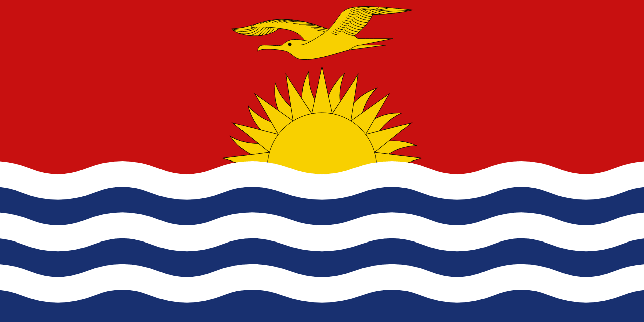
Kiribati Flag
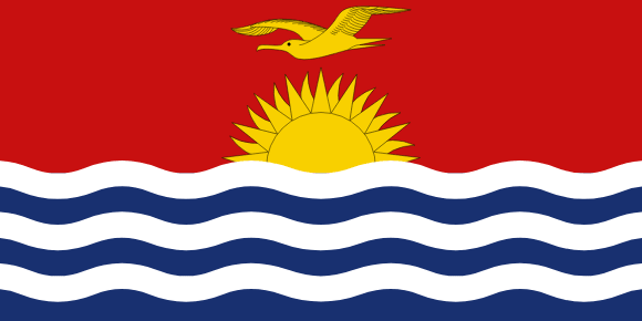
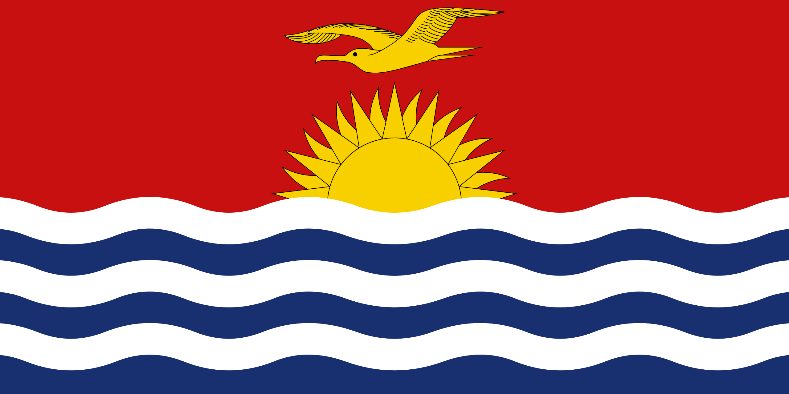
Kiribati's flag, also known as the “buraki ni Kiribati” in Gilbertese, is made up of red, yellow, blue, white, and gold colors. The flag's upper half is red, with a gold frigate bird (Fregata minor) soaring over a gold rising sun. In Kiribati tradition, this represents command of the sea, independence, and dancing patterns.
The lower half of the flag is blue, with three horizontal wavy white lines depicting the Pacific Ocean and the three archipelagoes of Gilbert, Phoenix, and Line Islands, which surround Kiribati. The sun's 17 beams signify the 16 Gilbert Islands and Banaba (former Ocean Island).
The flag's design is based on a badge designed by Sir Arthur Grimble in 1931 for the flag of the British colony of the Gilbert and Ellice Islands, which was officially adopted in 1937. The wavy blue and white stripes depict the Pacific Ocean, which surrounds Kiribati, while the sun indicates Kiribati's location on the Equator.
According to the National Identity Act of 1989, the flag represents power, freedom, Kiribati ethnic dance patterns, the tropical sun, and the Pacific Ocean.
Kiribati flag downloads
- completely free for commercial and non-commercial use (public domain)
- based on vector file from Wikipedia Commons
- PNG or WebP format (lossless compression)
- Right click on the links (save link as)
| Width | Height | PNG | WebP |
|---|---|---|---|
| 20px | 10px | ~0.1 KB | ~0.1 KB |
| 40px | 20px | ~0.4 KB | ~0.1 KB |
| 80px | 40px | ~0.7 KB | ~0.1 KB |
| 160px | 80px | ~2.6 KB | ~0.6 KB |
| Width | Height | PNG | WebP |
|---|---|---|---|
| 16px | 12px | ~0.1 KB | ~0.1 KB |
| 40px | 30px | ~0.4 KB | ~0.1 KB |
| 80px | 60px | ~0.8 KB | ~0.1 KB |
| 128px | 96px | ~2.5 KB | ~0.6 KB |
- completely free for commercial and non-commercial use (public domain)
- based on vector file from Wikipedia Commons
- PNG, WebP (lossless compression) or JPEG format (100% quality)
- Right click on the links (save link as)
| Width | Height | PNG | WebP | JPEG |
|---|---|---|---|---|
| 2560px | 1280px | ~2.6 KB | ~0.6 KB | ~34.9 KB |
| 1280px | 640px | ~0.7 KB | ~0.1 KB | ~13.0 KB |
| 640px | 320px | ~0.4 KB | ~0.1 KB | ~5.6 KB |
| 320px | 160px | ~0.2 KB | ~0.1 KB | ~2.8 KB |
| 160px | 80px | ~0.1 KB | ~0.1 KB | ~1.5 KB |
| 80px | 40px | ~0.1 KB | ~0.1 KB | ~0.9 KB |
| 40px | 20px | ~0.1 KB | ~0.1 KB | ~0.6 KB |
| 20px | 10px | ~0.1 KB | ~0.1 KB | ~0.4 KB |
- completely free for commercial and non-commercial use (public domain)
- based on vector file from Wikipedia Commons
- SVG, PDF (Adobe Acrobat), AI (Adobe Ilustrator) or EPS format
- Right click on the links (save link as)
| Format | SVG | AI | EPS | |
|---|---|---|---|---|
| Vector download | ~0.3 KB | ~12.5 KB | ~29.7 KB | ~1533.8 KB |
Country information
Kiribati is made up of 33 coral atolls, located in the central Pacific Ocean. The country is located on both sides of the equator, straddling the 180th meridian, and includes the easternmost islands in the world. The islands are spread over an area of 3.5 million square kilometers, making Kiribati one of the largest countries in the world in terms of land area. However, the country has a total land area of just 811 square kilometers, with most of the population living on the Tarawa atoll.
The capital of Kiribati is South Tarawa, which is a series of islets connected by causeways. The country gained its independence from the United Kingdom in 1979 and has a population of over 119,000 people. The economy of Kiribati is largely dependent on exports of copra and fisheries, with the country being one of the least developed in the world. Kiribati is a member of several international organizations, including the Pacific Community, the Commonwealth of Nations, and the United Nations.
Kiribati is also a member of the Alliance of Small Island States, and has made addressing climate change a key part of its international policy. The country is particularly vulnerable to the effects of climate change due to its location in the central Pacific Ocean, and has implemented several measures to mitigate and adapt to these changes. Despite its small size and limited resources, Kiribati has made significant efforts to address the impacts of climate change and protect its people and ecosystems.
| Independent | Yes |
| Country codes | KI, KIR (ISO 3166-1) |
| Official name | Independent and Sovereign Republic of Kiribati |
| Official languages | English and Gilbertese |
| Religion | 96.2% Christianity, 2.1% Baháʼí Faith, 1.7% Other / None |
| Capital city | South Tarawa |
| Continent | Oceania |
| Time zone | UTC+12, +13, +14 |
| Member of | United Nations |
| Commonwealth of Nations | |
| Pacific Community | |
| Population | 124,139 (2023) |
| Population density | 147 per Km2 (382 people per mi2) |
| Urban Population | 57.0 % of the population is urban (68,069 people in 2020) |
| Migrants (net) | -800 |
| Median age | 23.0 years |
| Total area | The total land area is 810 Km2 (313 sq. miles) |
| Highest point | / |
| Lowest point | Pacific Ocean |
| GDP per capita | $ 1,606 (World Bank, 2021) |
| Currency | Australian dollar ($, AUD) |
| Calling code | +686 |
| Internet TLD | .ki (click here to find and register domain name) |
| Country Wikipedia Page | Kiribati Wikipedia Page |
Main Cities by Population in Kiribati
| # | CITY NAME | POPULATION |
|---|---|---|
| 1 | Tarawa | 40,311 |
