Guam Flag

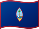
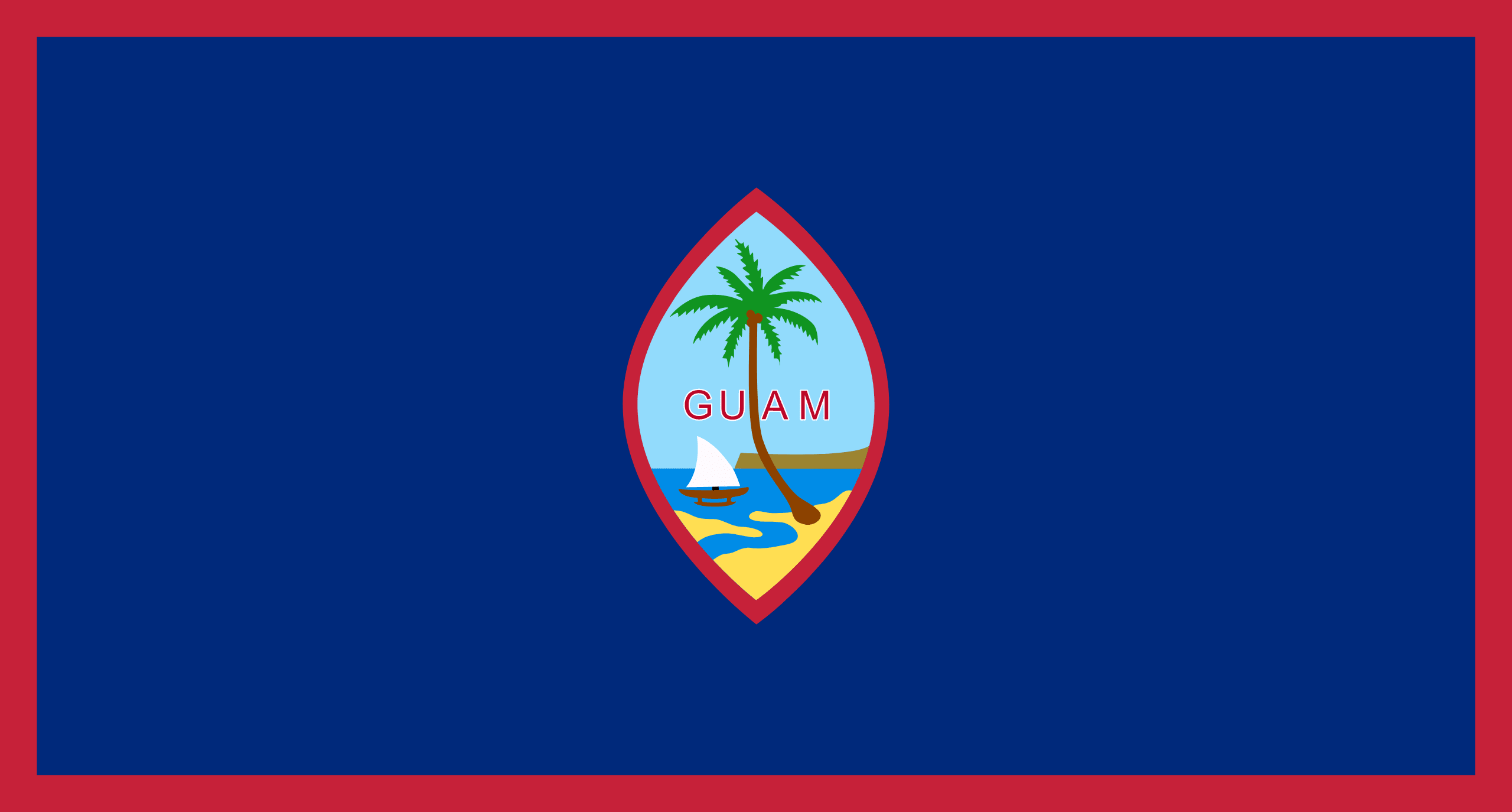
Guam's flag is dark blue with a thin red border on all sides. The blood shed during World War II, as well as the territory's history of Spanish control, are represented by the red border. The territorial seal, which is shaped like an almond and represents a proa sailing in Hagta Bay near the capital city of Hagta, is in the center of the flag, with the word “GUAM” printed in red letters.
The shape of the seal is inspired by the old Chamorro slingshot stones, while the landform in the background is Guam's Two Lovers Point rock.
Guam's flag was approved by Charles Alan Pownall, the military Governor of Guam at the time, on February 9, 1948. In addition to the territorial flag, each of Guam's villages has its own municipal flag, which was designed by the Mayors' Council with the assistance of artist Gerard Aflague. These municipal flags illustrate parts of each village's culture.
Guam flag downloads
- completely free for commercial and non-commercial use (public domain)
- based on vector file from Wikipedia Commons
- PNG or WebP format (lossless compression)
- Right click on the links (save link as)
| Width | Height | PNG | WebP |
|---|---|---|---|
| 20px | 11px | ~0.1 KB | ~0.1 KB |
| 40px | 21px | ~0.4 KB | ~0.1 KB |
| 80px | 43px | ~0.7 KB | ~0.1 KB |
| 160px | 86px | ~2.6 KB | ~0.6 KB |
| Width | Height | PNG | WebP |
|---|---|---|---|
| 16px | 12px | ~0.1 KB | ~0.1 KB |
| 40px | 30px | ~0.4 KB | ~0.1 KB |
| 80px | 60px | ~0.8 KB | ~0.1 KB |
| 128px | 96px | ~2.5 KB | ~0.6 KB |
- completely free for commercial and non-commercial use (public domain)
- based on vector file from Wikipedia Commons
- PNG, WebP (lossless compression) or JPEG format (100% quality)
- Right click on the links (save link as)
| Width | Height | PNG | WebP | JPEG |
|---|---|---|---|---|
| 2560px | 1374px | ~2.6 KB | ~0.6 KB | ~34.9 KB |
| 1280px | 687px | ~0.7 KB | ~0.1 KB | ~13.0 KB |
| 640px | 343px | ~0.4 KB | ~0.1 KB | ~5.6 KB |
| 320px | 172px | ~0.2 KB | ~0.1 KB | ~2.8 KB |
| 160px | 86px | ~0.1 KB | ~0.1 KB | ~1.5 KB |
| 80px | 43px | ~0.1 KB | ~0.1 KB | ~0.9 KB |
| 40px | 21px | ~0.1 KB | ~0.1 KB | ~0.6 KB |
| 20px | 11px | ~0.1 KB | ~0.1 KB | ~0.4 KB |
- completely free for commercial and non-commercial use (public domain)
- based on vector file from Wikipedia Commons
- SVG, PDF (Adobe Acrobat), AI (Adobe Ilustrator) or EPS format
- Right click on the links (save link as)
| Format | SVG | AI | EPS | |
|---|---|---|---|---|
| Vector download | ~0.3 KB | ~12.5 KB | ~29.7 KB | ~1533.8 KB |
Country information
Guam is an unincorporated territory of the United States located in the western Pacific Ocean. It is the largest and southernmost of the Mariana Islands, and is the westernmost territory of the United States. The capital of Guam is Hagåtña, which is located on the west coast of the island and is the largest city in the territory.
Guam has a population of approximately 175,000 people, and the official languages are English and Chamorro. The territory has a diverse population, with a mix of Pacific Islander, Asian, and North American influences. The main religions in Guam are Christianity and traditional Chamorro spirituality.
Guam has a tropical climate, with high temperatures and high humidity throughout the year. The territory is known for its beautiful beaches and clear blue waters, which make it a popular tourist destination.
The economy of Guam is primarily based on tourism, with the territory attracting millions of visitors each year. The military is also an important contributor to the economy, with a significant number of military personnel and their families stationed on the island. The manufacturing and service sectors are also significant contributors to the economy.
As an unincorporated territory of the United States, Guam is subject to the jurisdiction of the United States federal government, but it is not a state. The territory is self-governing, with a governor as the head of government and a delegate to the United States Congress.
Overall, Guam is a beautiful and vibrant territory with a rich culture and a unique natural environment. Its strong tourism industry and strategic location in the Pacific make it an important player in regional and international affairs. Its beautiful beaches, rich history, and diverse population make it an attractive destination for tourists.
| Independent | No |
| Country codes | GU, GUM (ISO 3166-1) |
| Official name | Guam |
| Official languages | English and Chamorro |
| Religion | 94.1% Christianity, 1.7% No religion, 1.5% Folk religions, 1.1% Buddhism, 1.6% Other |
| Capital city | Hagåtña |
| Continent | Oceania |
| Time zone | UTC+10:00 (ChST) |
| Member of | Pacific Community |
| Population | 172,534 (2023) |
| Population density | 313 per Km2 (809 people per mi2) |
| Urban Population | 94.9 % of the population is urban (160,185 people in 2020) |
| Migrants (net) | -506 |
| Median age | 31.4 years |
| Total area | The total land area is 540 Km2 (208 sq. miles) |
| Highest point | Mount Lamlam (406 m, 1 332 ft) |
| Lowest point | North Pacific Ocean |
| GDP per capita | $ 35,904 (World Bank, 2021) |
| Currency | United States dollar ($, USD) |
| Calling code | +1671 |
| Internet TLD | .gu (click here to find and register domain name) |
| Country Wikipedia Page | Guam Wikipedia Page |
Main Cities by Population in Guam
| # | CITY NAME | POPULATION |
|---|---|---|
| 1 | Dededo Village | 44,943 |
| 2 | Yigo Village | 20,539 |
| 3 | Tamuning | 19,685 |
| 3 | Tamuning-Tumon-Harmon Village | 19,685 |
| 4 | Mangilao Village | 15,191 |
