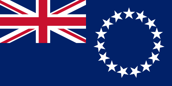
Cook Islands Flag

The current flag of the Cook Islands consists of a blue ensign with the Union Flag in the upper left corner and a circle of 15 white five-pointed stars in the right half. The blue represents the ocean that surrounds the Cook Islands and the peaceful nature of the people.
The Union Flag symbolizes the country's historic ties to the United Kingdom and the Commonwealth of Nations. The 15 stars represent the 15 islands that make up the Cook Islands, including Tongareva, Rakahanga, Manihiki, Pukapuka, Nassau, Suwarrow, Palmerston, Aitutaki, Manuae, Takutea, Atiu, Mitiaro, Mauke, Rarotonga, and Mangaia.
The circle of stars represents unity and strength, as well as the unity of the 15 islands as one people. The flag was officially adopted in 1979, replacing a previous design that had been in use since 1974.
Cook Islands flag downloads
- completely free for commercial and non-commercial use (public domain)
- based on vector file from Wikipedia Commons
- PNG or WebP format (lossless compression)
- Right click on the links (save link as)
| Width | Height | PNG | WebP |
|---|---|---|---|
| 20px | 10px | ~0.1 KB | ~0.1 KB |
| 40px | 20px | ~0.4 KB | ~0.1 KB |
| 80px | 40px | ~0.7 KB | ~0.1 KB |
| 160px | 80px | ~2.6 KB | ~0.6 KB |
| Width | Height | PNG | WebP |
|---|---|---|---|
| 16px | 12px | ~0.1 KB | ~0.1 KB |
| 40px | 30px | ~0.4 KB | ~0.1 KB |
| 80px | 60px | ~0.8 KB | ~0.1 KB |
| 128px | 96px | ~2.5 KB | ~0.6 KB |
- completely free for commercial and non-commercial use (public domain)
- based on vector file from Wikipedia Commons
- PNG, WebP (lossless compression) or JPEG format (100% quality)
- Right click on the links (save link as)
| Width | Height | PNG | WebP | JPEG |
|---|---|---|---|---|
| 2560px | 1280px | ~2.6 KB | ~0.6 KB | ~34.9 KB |
| 1280px | 640px | ~0.7 KB | ~0.1 KB | ~13.0 KB |
| 640px | 320px | ~0.4 KB | ~0.1 KB | ~5.6 KB |
| 320px | 160px | ~0.2 KB | ~0.1 KB | ~2.8 KB |
| 160px | 80px | ~0.1 KB | ~0.1 KB | ~1.5 KB |
| 80px | 40px | ~0.1 KB | ~0.1 KB | ~0.9 KB |
| 40px | 20px | ~0.1 KB | ~0.1 KB | ~0.6 KB |
| 20px | 10px | ~0.1 KB | ~0.1 KB | ~0.4 KB |
- completely free for commercial and non-commercial use (public domain)
- based on vector file from Wikipedia Commons
- SVG, PDF (Adobe Acrobat), AI (Adobe Ilustrator) or EPS format
- Right click on the links (save link as)
| Format | SVG | AI | EPS | |
|---|---|---|---|---|
| Vector download | ~0.3 KB | ~12.5 KB | ~29.7 KB | ~1533.8 KB |
Country information
The Cook Islands are a self-governing parliamentary democracy in free association with New Zealand, located in the South Pacific Ocean. The Cook Islands consist of 15 islands spread over a vast area of the Pacific, and they are home to about 15,000 people.
The Cook Islands have a diverse and multicultural society, with people of Polynesian, Maori, and European descent living on the islands. The official languages are English and Cook Islands Maori, and the country has a predominantly Christian population.
The Cook Islands have a unique and varied landscape, with white sandy beaches, crystal-clear waters, and lush vegetation. The climate is warm and tropical, and the islands are known for their snorkeling and diving opportunities.
Tourism is an important industry in the Cook Islands, with visitors coming to enjoy the beautiful beaches and natural scenery. The islands also have a small agriculture and fishing industry.
The Cook Islands are a self-governing parliamentary democracy in free association with New Zealand. They have a parliament and a prime minister, and they are represented in the New Zealand parliament.
| Independent | No |
| Country codes | CK, COK (ISO 3166-1) |
| Official name | Cook Islands |
| Official languages | English, Cook Islands Māori (including Pukapukan) |
| Religion | / |
| Capital city | Avarua |
| Continent | Oceania |
| Time zone | UTC-10 (CKT) |
| Member of | Pacific Community |
| Population | 17,604 (2023) |
| Population density | 73 per Km2 (190 people per mi2) |
| Urban Population | 75.3 % of the population is urban (13,223 people in 2020) |
| Migrants (net) | / |
| Median age | / |
| Total area | The total land area is 240 Km2 (93 sq. miles) |
| Highest point | Te Manga on Rarotonga (652 m, 2 139 ft) |
| Lowest point | South Pacific Ocean |
| GDP per capita | $ / (World Bank, 2021) |
| Currency | New Zealand dollar ($, NZD) |
| Calling code | +682 |
| Internet TLD | .ck (click here to find and register domain name) |
| Country Wikipedia Page | Cook Islands Wikipedia Page |
Main Cities by Population in Cook Islands
| # | CITY NAME | POPULATION |
|---|---|---|
| 1 | / | / |
