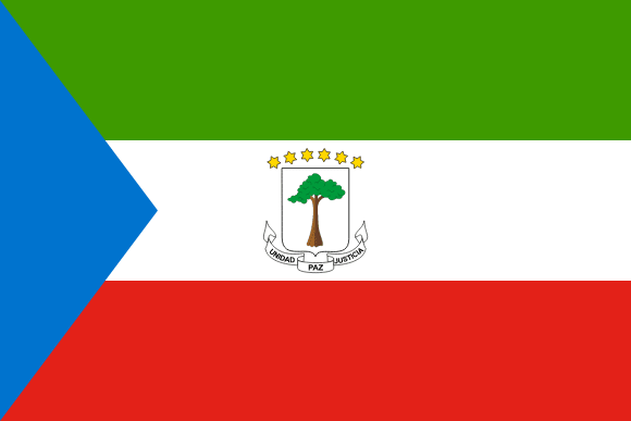
Equatorial Guinea Flag

Equatorial Guinea's flag, which includes a horizontal tricolor of green, white, and red stripes with a blue triangle at the hoist, was officially adopted on August 21, 1979.
The map's six stars reflect the country's mainland and five islands. Green signifies the country's natural riches, farmland, and forests; blue represents the sea that connects the mainland to the islands; white represents peace; and red represents the blood poured by those who battled for independence.
During Francisco Nguema's dictatorship, the flag was changed and a new national emblem was adopted. The original flag was reinstated after Nguema was deposed.
Equatorial Guinea flag downloads
- completely free for commercial and non-commercial use (public domain)
- based on vector file from Wikipedia Commons
- PNG or WebP format (lossless compression)
- Right click on the links (save link as)
| Width | Height | PNG | WebP |
|---|---|---|---|
| 20px | 13px | ~0.1 KB | ~0.1 KB |
| 40px | 27px | ~0.4 KB | ~0.1 KB |
| 80px | 53px | ~0.7 KB | ~0.1 KB |
| 160px | 107px | ~2.6 KB | ~0.6 KB |
| Width | Height | PNG | WebP |
|---|---|---|---|
| 16px | 12px | ~0.1 KB | ~0.1 KB |
| 40px | 30px | ~0.4 KB | ~0.1 KB |
| 80px | 60px | ~0.8 KB | ~0.1 KB |
| 128px | 96px | ~2.5 KB | ~0.6 KB |
- completely free for commercial and non-commercial use (public domain)
- based on vector file from Wikipedia Commons
- PNG, WebP (lossless compression) or JPEG format (100% quality)
- Right click on the links (save link as)
| Width | Height | PNG | WebP | JPEG |
|---|---|---|---|---|
| 2560px | 1707px | ~2.6 KB | ~0.6 KB | ~34.9 KB |
| 1280px | 853px | ~0.7 KB | ~0.1 KB | ~13.0 KB |
| 640px | 427px | ~0.4 KB | ~0.1 KB | ~5.6 KB |
| 320px | 213px | ~0.2 KB | ~0.1 KB | ~2.8 KB |
| 160px | 107px | ~0.1 KB | ~0.1 KB | ~1.5 KB |
| 80px | 53px | ~0.1 KB | ~0.1 KB | ~0.9 KB |
| 40px | 27px | ~0.1 KB | ~0.1 KB | ~0.6 KB |
| 20px | 13px | ~0.1 KB | ~0.1 KB | ~0.4 KB |
- completely free for commercial and non-commercial use (public domain)
- based on vector file from Wikipedia Commons
- SVG, PDF (Adobe Acrobat), AI (Adobe Ilustrator) or EPS format
- Right click on the links (save link as)
| Format | SVG | AI | EPS | |
|---|---|---|---|---|
| Vector download | ~0.3 KB | ~12.5 KB | ~29.7 KB | ~1533.8 KB |
Country information
Equatorial Guinea is a country located in Central Africa, bordered by Cameroon to the north, Gabon to the south and east, and the Atlantic Ocean to the west. It is a small country with a land area of about 10,000 square miles, and it is home to over 1.4 million people, making it the 154th most populous country in the world.
Equatorial Guinea has a diverse and multicultural society, with people of Fang, Bubi, and other African descent living in the country. The official languages are Spanish and French, and the country has a predominantly Roman Catholic population.
Equatorial Guinea has a varied and unique landscape, ranging from mountains to forests to coastlines. The climate is tropical, with hot and humid conditions year-round. The country is known for its beautiful natural scenery and history, and it is a popular tourist destination.
Equatorial Guinea has a presidential system of government and is a republic. It is a member of the African Union, the Union of Latin American and Caribbean States, and the United Nations, and it has a strong relationship with other countries in the region.
Equatorial Guinea has a strong and diversified economy, with a wide range of industries including agriculture, manufacturing, and tourism. It is a major exporter of oil, timber, and cocoa.
| Independent | Yes |
| Country codes | GQ, GNQ (ISO 3166-1) |
| Official name | Republic of Equatorial Guinea |
| Official languages | Spanish (national language), French, Portuguese |
| Religion | 88.7% Christianity, 5.0% No religion, 4.0% Islam, 1.7% Traditional faiths, 0.6% Others |
| Capital city | Malabo |
| Continent | Africa |
| Time zone | UTC+1 (WAT) |
| Member of | United Nations |
| African Union | |
| Population | 1,519,666 (2023) |
| Population density | 50 per Km2 (130 people per mi2) |
| Urban Population | 73.3 % of the population is urban (1,027,990 people in 2020) |
| Migrants (net) | 16,000 |
| Median age | 22.3 years |
| Total area | The total land area is 28,050 Km2 (10,830 sq. miles) |
| Highest point | Pico Basile on Bioko (3 008 m, 9 869 ft) |
| Lowest point | North Atlantic Ocean |
| GDP per capita | $ 7,506 (World Bank, 2021) |
| Currency | Central African CFA franc (Fr, XAF) |
| Calling code | +240 |
| Internet TLD | .gq (click here to find and register domain name) |
| Country Wikipedia Page | Equatorial Guinea Wikipedia Page |
Main Cities by Population in Equatorial Guinea
| # | CITY NAME | POPULATION |
|---|---|---|
| 1 | Bata | 173,046 |
| 2 | Malabo | 155,963 |
| 3 | Ebebiyin | 24,831 |
