Caribbean Netherlands Flag

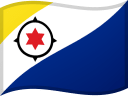
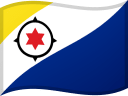
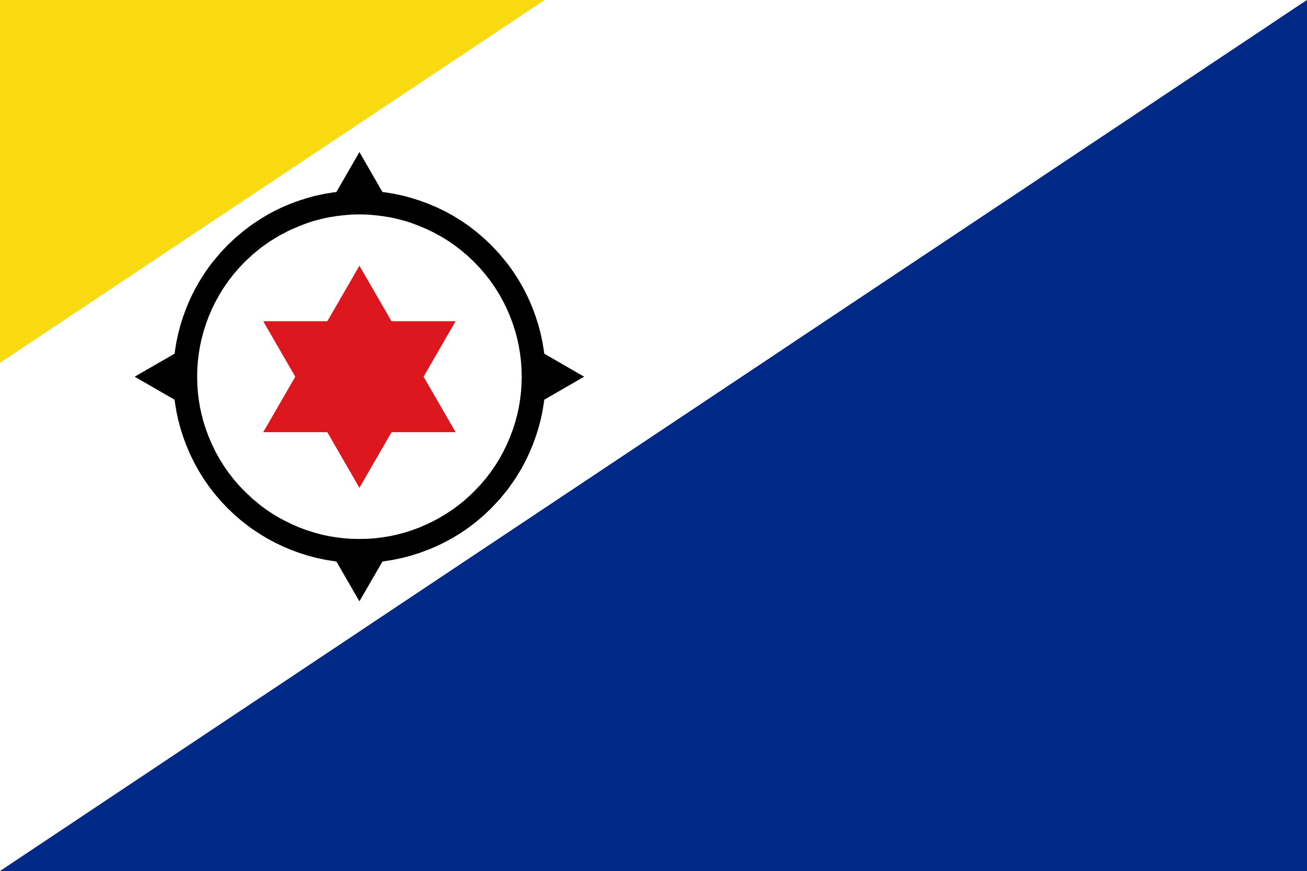
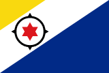
The flag of the Caribbean Netherlands, specifically the island of Bonaire, consists of a large dark blue band in the lower right corner and a smaller yellow band in the upper left corner, separated by a white strip. The dark blue and yellow bands represent the sea and sun, respectively, while the white strip represents the sky.
Inside the white strip is a black compass and a red six-pointed star. The black compass represents the population of Bonaire as a seafaring people, and the arrows around it symbolize equality in the four cardinal directions of the compass.
The red six-pointed star represents the six original villages of Bonaire: Antriol, Nikiboko, Nort Saliña, Playa, Rincon, and Tera Korá. The flag was adopted in 1981 and is celebrated on Flag Day on September 6th each year, marking the traditional date that Europeans first arrived on the island. The flag was developed with the help of professional vexillologist Whitney Smith.
Caribbean Netherlands flag downloads
- completely free for commercial and non-commercial use (public domain)
- based on vector file from Wikipedia Commons
- PNG or WebP format (lossless compression)
- Right click on the links (save link as)
| Width | Height | PNG | WebP |
|---|---|---|---|
| 20px | 13px | ~0.1 KB | ~0.1 KB |
| 40px | 27px | ~0.4 KB | ~0.1 KB |
| 80px | 53px | ~0.7 KB | ~0.1 KB |
| 160px | 107px | ~2.6 KB | ~0.6 KB |
| Width | Height | PNG | WebP |
|---|---|---|---|
| 16px | 12px | ~0.1 KB | ~0.1 KB |
| 40px | 30px | ~0.4 KB | ~0.1 KB |
| 80px | 60px | ~0.8 KB | ~0.1 KB |
| 128px | 96px | ~2.5 KB | ~0.6 KB |
- completely free for commercial and non-commercial use (public domain)
- based on vector file from Wikipedia Commons
- PNG, WebP (lossless compression) or JPEG format (100% quality)
- Right click on the links (save link as)
| Width | Height | PNG | WebP | JPEG |
|---|---|---|---|---|
| 2560px | 1707px | ~2.6 KB | ~0.6 KB | ~34.9 KB |
| 1280px | 853px | ~0.7 KB | ~0.1 KB | ~13.0 KB |
| 640px | 427px | ~0.4 KB | ~0.1 KB | ~5.6 KB |
| 320px | 213px | ~0.2 KB | ~0.1 KB | ~2.8 KB |
| 160px | 107px | ~0.1 KB | ~0.1 KB | ~1.5 KB |
| 80px | 53px | ~0.1 KB | ~0.1 KB | ~0.9 KB |
| 40px | 27px | ~0.1 KB | ~0.1 KB | ~0.6 KB |
| 20px | 13px | ~0.1 KB | ~0.1 KB | ~0.4 KB |
- completely free for commercial and non-commercial use (public domain)
- based on vector file from Wikipedia Commons
- SVG, PDF (Adobe Acrobat), AI (Adobe Ilustrator) or EPS format
- Right click on the links (save link as)
| Format | SVG | AI | EPS | |
|---|---|---|---|---|
| Vector download | ~0.3 KB | ~12.5 KB | ~29.7 KB | ~1533.8 KB |
Country information
The Caribbean Netherlands, also known as the BES islands (Bonaire, Sint Eustatius, and Saba), are three special municipalities of the Netherlands located in the Caribbean Sea. They are part of the Netherlands Antilles, which was a constituent country of the Kingdom of the Netherlands until 2010.
The BES islands have a population of about 25,000 people, and the official language is Dutch. The islands have a diverse and multicultural society, with people of African, Dutch, and other Caribbean descent living there.
The BES islands have a unique and varied landscape, with white sandy beaches, rugged mountains, and lush forests. The climate is warm and tropical, and the islands are known for their clear, turquoise waters and coral reefs.
Tourism is an important industry in the BES islands, with visitors coming to enjoy the beautiful beaches and natural scenery. The islands also have a small agricultural sector, with crops including aloes, vegetables, and livestock.
The Caribbean Netherlands are part of the Kingdom of the Netherlands and are self-governing. They have a parliamentary democracy and are represented in the Dutch parliament.
The BES islands have a rich and vibrant culture, with a diverse range of traditional music, dance, and art forms. They are also home to several protected areas, including the Saba National Marine Park and the Bonaire National Marine Park, which are important for the conservation of marine ecosystems.
| Independent | No |
| Country codes | BQ, BES (ISO 3166-1) |
| Official name | Bonaire, Sint Eustatius and Saba |
| Official languages | Dutch |
| Religion | / |
| Capital city | / |
| Continent | North America |
| Time zone | UTC−4 (AST) |
| Member of | / |
| Population | 26,835 (2023) |
| Population density | 80 per Km2 (207 people per mi2) |
| Urban Population | 75.0 % of the population is urban (19,672 people in 2020) |
| Migrants (net) | / |
| Median age | / |
| Total area | The total land area is 328 Km2 (127 sq. miles) |
| Highest point | / |
| Lowest point | / |
| GDP per capita | $ / (World Bank, 2021) |
| Currency | United States dollar ($, USD) |
| Calling code | +599 |
| Internet TLD | .bq, .nl (click here to find and register domain name) |
| Country Wikipedia Page | Caribbean Netherlands Wikipedia Page |
Main Cities by Population in Caribbean Netherlands
| # | CITY NAME | POPULATION |
|---|---|---|
| 1 | / | / |
