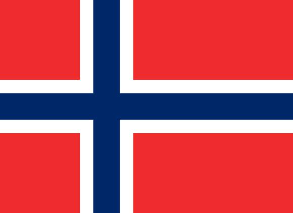
Bouvet Island Flag

The flag of Bouvet Island is a red flag with a navy blue Scandinavian cross in the center. The cross is fimbriated in white, which means that it is surrounded by a white border. The cross extends to the edges of the flag, and the vertical part of the cross is shifted to the hoist side, similar to the Danish flag, known as the Dannebrog.
The red color of the flag represents bravery, while the blue cross represents the country's strong ties to Scandinavia. The white fimbriation represents peace and purity.
The flag of Bouvet Island is an important symbol of the territory's connection to Norway and its shared history and culture. It is displayed at official ceremonies and events, and is a source of pride for the people of Bouvet Island. So, the flag of Bouvet Island is a reminder of the territory's unique place in the world and its strong ties to its parent country, Norway.
Bouvet Island flag downloads
- completely free for commercial and non-commercial use (public domain)
- based on vector file from Wikipedia Commons
- PNG or WebP format (lossless compression)
- Right click on the links (save link as)
| Width | Height | PNG | WebP |
|---|---|---|---|
| 20px | 15px | ~0.1 KB | ~0.1 KB |
| 40px | 29px | ~0.4 KB | ~0.1 KB |
| 80px | 58px | ~0.7 KB | ~0.1 KB |
| 160px | 116px | ~2.6 KB | ~0.6 KB |
| Width | Height | PNG | WebP |
|---|---|---|---|
| 16px | 12px | ~0.1 KB | ~0.1 KB |
| 40px | 30px | ~0.4 KB | ~0.1 KB |
| 80px | 60px | ~0.8 KB | ~0.1 KB |
| 128px | 96px | ~2.5 KB | ~0.6 KB |
- completely free for commercial and non-commercial use (public domain)
- based on vector file from Wikipedia Commons
- PNG, WebP (lossless compression) or JPEG format (100% quality)
- Right click on the links (save link as)
| Width | Height | PNG | WebP | JPEG |
|---|---|---|---|---|
| 2560px | 1862px | ~2.6 KB | ~0.6 KB | ~34.9 KB |
| 1280px | 931px | ~0.7 KB | ~0.1 KB | ~13.0 KB |
| 640px | 465px | ~0.4 KB | ~0.1 KB | ~5.6 KB |
| 320px | 233px | ~0.2 KB | ~0.1 KB | ~2.8 KB |
| 160px | 116px | ~0.1 KB | ~0.1 KB | ~1.5 KB |
| 80px | 58px | ~0.1 KB | ~0.1 KB | ~0.9 KB |
| 40px | 29px | ~0.1 KB | ~0.1 KB | ~0.6 KB |
| 20px | 15px | ~0.1 KB | ~0.1 KB | ~0.4 KB |
- completely free for commercial and non-commercial use (public domain)
- based on vector file from Wikipedia Commons
- SVG, PDF (Adobe Acrobat), AI (Adobe Ilustrator) or EPS format
- Right click on the links (save link as)
| Format | SVG | AI | EPS | |
|---|---|---|---|---|
| Vector download | ~0.3 KB | ~12.5 KB | ~29.7 KB | ~1533.8 KB |
Country information
Bouvet Island is a small, uninhabited island located in the South Atlantic Ocean, about 1,000 miles off the coast of South Africa. It is a dependent territory of Norway, and has a total land area of about 19 square miles. Bouvet Island has a rich history, but it has never been permanently inhabited and has a very limited human presence.
The history of Bouvet Island dates back to the early 19th century, when it was discovered by a French explorer named Jean-Baptiste Charles Bouvet de Lozier. Despite its small size and remote location, the island has played an important role in the exploration and mapping of the South Atlantic Ocean. In the 20th century, the island was claimed by Norway, and it is now protected as a nature reserve.
Bouvet Island is known for its stunning natural beauty, with a rugged and mountainous landscape covered in glaciers and snow. The island is home to a number of protected areas, including the Bouvet Island Nature Reserve, which is home to a variety of plant and animal species.
Despite its small size and remote location, Bouvet Island has a rich history and cultural significance. It has been visited by a number of explorers and scientists over the years, and has played an important role in the study of the South Atlantic Ocean and the exploration of the polar regions.
| Independent | No |
| Country codes | BV, BVT (ISO 3166-1) |
| Official name | Bouvet Island |
| Official languages | Norwegian |
| Religion | / |
| Capital city | / |
| Continent | / |
| Time zone | / |
| Member of | / |
| Population | 0 (2023) |
| Population density | / |
| Urban Population | / |
| Migrants (net) | / |
| Median age | / |
| Total area | The total land area is 49 km2 (19 sq mi) |
| Highest point | Olavtoppen (935 m, 3 068 ft) |
| Lowest point | South Atlantic Ocean |
| GDP per capita | / |
| Currency | Norwegian krone (kr, NOK) |
| Calling code | +47 |
| Internet TLD | .bv (click here to find and register domain name) |
| Country Wikipedia Page | Bouvet Island Wikipedia Page |
Main Cities by Population in Bouvet Island
| # | CITY NAME | POPULATION |
|---|---|---|
| 1 | / | / |
