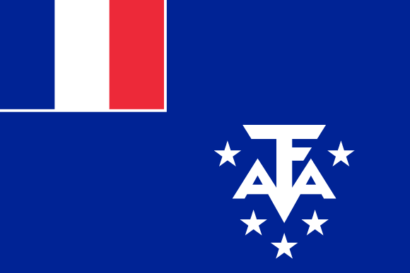
French Southern and Antarctic Lands Flag

The French Southern and Antarctic Lands flag (French: Drapeau des Terres australes et antarctiques françaises) is a flag representing France's overseas territory, which includes Adélie Land, the Crozet Islands, the Kerguelen Islands, the Saint Paul and Amsterdam Islands, and the Scattered Islands.
The flag, which was adopted on February 23, 2007, features the French tricolor in the canton, bordered by a white border. The letters “T.A.A.F.” (the abbreviation for the French name for the territory: “terres australes et antarctiques françaises”) form a white monogram surrounded by five white stars in the lower fly.
The monogram is designed to seem like an anchor. The stars are frequently assumed to represent each of the territory's five regions, however this was not indicated in the flag's adoption decree.
French Southern and Antarctic Lands flag downloads
- completely free for commercial and non-commercial use (public domain)
- based on vector file from Wikipedia Commons
- PNG or WebP format (lossless compression)
- Right click on the links (save link as)
| Width | Height | PNG | WebP |
|---|---|---|---|
| 20px | 13px | ~0.1 KB | ~0.1 KB |
| 40px | 27px | ~0.4 KB | ~0.1 KB |
| 80px | 53px | ~0.7 KB | ~0.1 KB |
| 160px | 107px | ~2.6 KB | ~0.6 KB |
| Width | Height | PNG | WebP |
|---|---|---|---|
| 16px | 12px | ~0.1 KB | ~0.1 KB |
| 40px | 30px | ~0.4 KB | ~0.1 KB |
| 80px | 60px | ~0.8 KB | ~0.1 KB |
| 128px | 96px | ~2.5 KB | ~0.6 KB |
- completely free for commercial and non-commercial use (public domain)
- based on vector file from Wikipedia Commons
- PNG, WebP (lossless compression) or JPEG format (100% quality)
- Right click on the links (save link as)
| Width | Height | PNG | WebP | JPEG |
|---|---|---|---|---|
| 2560px | 1707px | ~2.6 KB | ~0.6 KB | ~34.9 KB |
| 1280px | 853px | ~0.7 KB | ~0.1 KB | ~13.0 KB |
| 640px | 427px | ~0.4 KB | ~0.1 KB | ~5.6 KB |
| 320px | 213px | ~0.2 KB | ~0.1 KB | ~2.8 KB |
| 160px | 107px | ~0.1 KB | ~0.1 KB | ~1.5 KB |
| 80px | 53px | ~0.1 KB | ~0.1 KB | ~0.9 KB |
| 40px | 27px | ~0.1 KB | ~0.1 KB | ~0.6 KB |
| 20px | 13px | ~0.1 KB | ~0.1 KB | ~0.4 KB |
- completely free for commercial and non-commercial use (public domain)
- based on vector file from Wikipedia Commons
- SVG, PDF (Adobe Acrobat), AI (Adobe Ilustrator) or EPS format
- Right click on the links (save link as)
| Format | SVG | AI | EPS | |
|---|---|---|---|---|
| Vector download | ~0.3 KB | ~12.5 KB | ~29.7 KB | ~1533.8 KB |
Country information
The French Southern and Antarctic Lands (French: Terres australes et antarctiques françaises, TAAF) is a French overseas territory located in the southern Indian Ocean. It consists of four main territories: Kerguelen Islands, Crozet Islands, Saint-Paul and Amsterdam Islands, and the Adélie Land.
The French Southern and Antarctic Lands have a population of just over 500 people, most of whom live on the Kerguelen Islands. The capital of the territory is Martin-de-Viviès, which is located on the Kerguelen Islands. The official language of the French Southern and Antarctic Lands is French, and the currency is the Euro.
The French Southern and Antarctic Lands have a harsh and isolated climate, with cold temperatures and high winds throughout the year. The region is home to a number of unique species of plants and animals, including seals, penguins, and seabirds.
The economy of the French Southern and Antarctic Lands is primarily based on research and scientific exploration. The region is home to several research stations and is an important center for the study of geology, biology, and climate science.
As an overseas territory of France, the French Southern and Antarctic Lands are a full part of the European Union and the eurozone. The territory is represented in the French National Assembly and the Senate by a single delegate.
Overall, the French Southern and Antarctic Lands are a remote and little-known region with a rich history and a unique natural environment. Its harsh climate and isolation make it an important center for scientific research, and its rich ecosystem is a source of fascination for scientists and naturalists from around the world.
| Independent | No |
| Country codes | TF, ATF (ISO 3166-1) |
| Official name | Territory of the French Southern and Antarctic Lands |
| Official languages | French |
| Religion | / |
| Capital city | Port-aux-Français |
| Continent | / |
| Time zone | UTC+04:00, UTC+05:00, UTC+10:00 |
| Member of | / |
| Population | / (2023) |
| Population density | / |
| Urban Population | / |
| Migrants (net) | / |
| Median age | / |
| Total area | The total land area is 439,666.4 km2 (169,756.1 sq mi) |
| Highest point | Mont Ross on Kerguelen Islands (1 850 m, 6 070 ft) |
| Lowest point | Indian Ocean |
| GDP per capita | $ / (World Bank, 2021) |
| Currency | Euro (€, EUR) |
| Calling code | +262 |
| Internet TLD | .tf (click here to find and register domain name) |
| Country Wikipedia Page | French Southern and Antarctic Lands Wikipedia Page |
Main Cities by Population in French Southern and Antarctic Lands
| # | CITY NAME | POPULATION |
|---|---|---|
| 1 | / | / |
