Christmas Island Flag

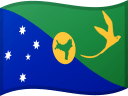
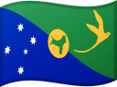
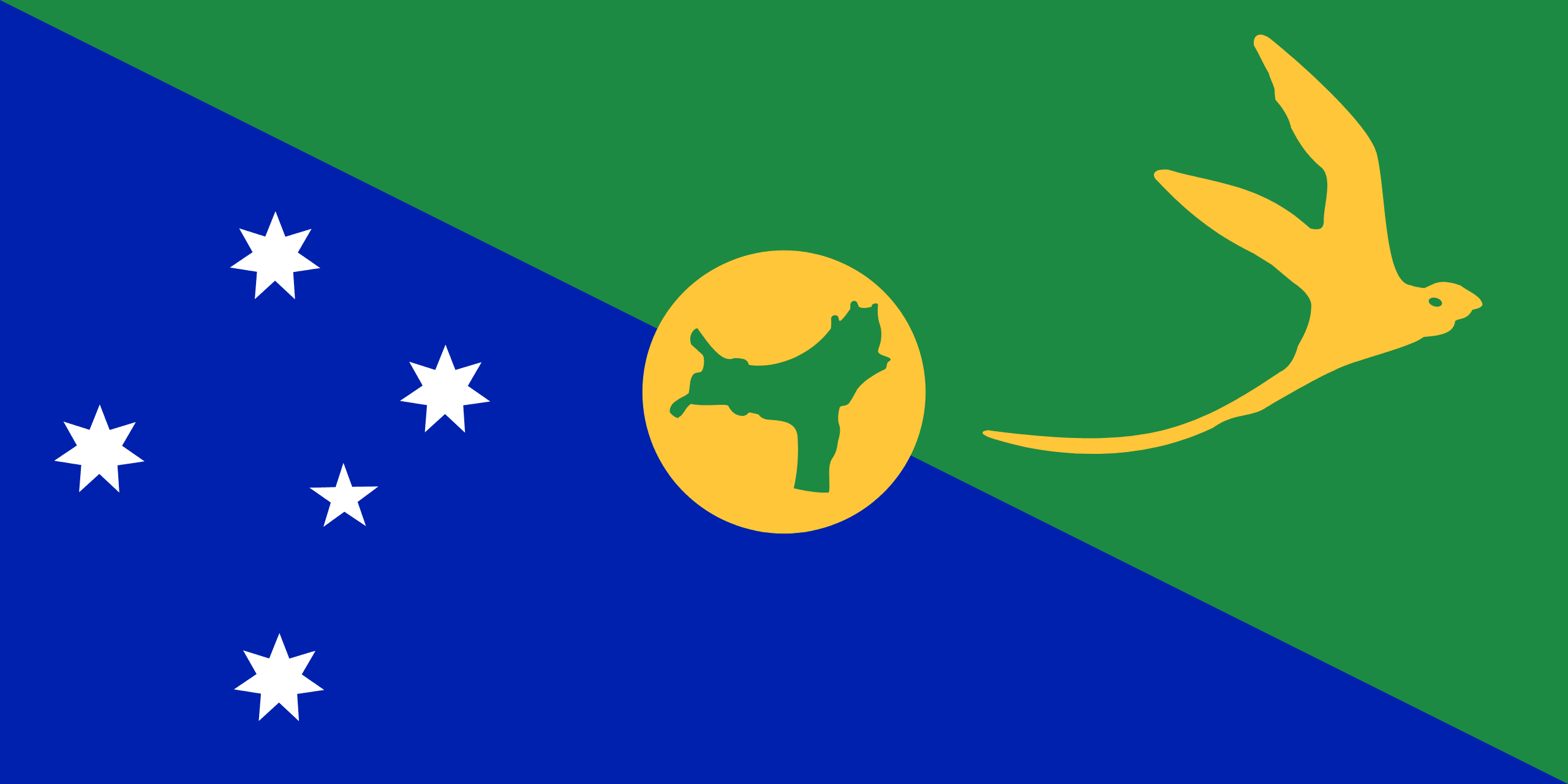
The flag of Christmas Island is a green and blue background, split from the top left corner to the bottom right, representing the land and sea respectively. The Southern Cross constellation appears in the bottom left of the flag, similar to the flag of Australia. In the top right, there is a golden bosun bird, a symbol of the island.
In the center of the flag, on a golden disc, is a map of the island in green. The disc itself was originally included to offset the green color of the map, but has become linked to the mining industry.
The flag was unofficially adopted in 1986 after being chosen as the winner in a competition for a flag for the territory. It was made official in 2002 on Australia Day when the administrator of the territory presented the flag to the Christmas Island Shire. It was designed by Tony Couch of Sydney, Australia.
Christmas Island flag downloads
- completely free for commercial and non-commercial use (public domain)
- based on vector file from Wikipedia Commons
- PNG or WebP format (lossless compression)
- Right click on the links (save link as)
| Width | Height | PNG | WebP |
|---|---|---|---|
| 20px | 10px | ~0.1 KB | ~0.1 KB |
| 40px | 20px | ~0.4 KB | ~0.1 KB |
| 80px | 40px | ~0.7 KB | ~0.1 KB |
| 160px | 80px | ~2.6 KB | ~0.6 KB |
| Width | Height | PNG | WebP |
|---|---|---|---|
| 16px | 12px | ~0.1 KB | ~0.1 KB |
| 40px | 30px | ~0.4 KB | ~0.1 KB |
| 80px | 60px | ~0.8 KB | ~0.1 KB |
| 128px | 96px | ~2.5 KB | ~0.6 KB |
- completely free for commercial and non-commercial use (public domain)
- based on vector file from Wikipedia Commons
- PNG, WebP (lossless compression) or JPEG format (100% quality)
- Right click on the links (save link as)
| Width | Height | PNG | WebP | JPEG |
|---|---|---|---|---|
| 2560px | 1280px | ~2.6 KB | ~0.6 KB | ~34.9 KB |
| 1280px | 640px | ~0.7 KB | ~0.1 KB | ~13.0 KB |
| 640px | 320px | ~0.4 KB | ~0.1 KB | ~5.6 KB |
| 320px | 160px | ~0.2 KB | ~0.1 KB | ~2.8 KB |
| 160px | 80px | ~0.1 KB | ~0.1 KB | ~1.5 KB |
| 80px | 40px | ~0.1 KB | ~0.1 KB | ~0.9 KB |
| 40px | 20px | ~0.1 KB | ~0.1 KB | ~0.6 KB |
| 20px | 10px | ~0.1 KB | ~0.1 KB | ~0.4 KB |
- completely free for commercial and non-commercial use (public domain)
- based on vector file from Wikipedia Commons
- SVG, PDF (Adobe Acrobat), AI (Adobe Ilustrator) or EPS format
- Right click on the links (save link as)
| Format | SVG | AI | EPS | |
|---|---|---|---|---|
| Vector download | ~0.3 KB | ~12.5 KB | ~29.7 KB | ~1533.8 KB |
Country information
Christmas Island is an Australian territory located in the Indian Ocean, about 2,600 miles northwest of Perth. It is an island with a land area of about 60 square miles, and it is home to about 2,000 people.
Christmas Island has a diverse and multicultural society, with people of Chinese, Malay, and European descent living on the island. The official language is English, and the island has a predominantly Buddhist population.
Christmas Island has a unique and varied landscape, with rainforests, cliffs, and sandy beaches. The climate is tropical, and the island is known for its beautiful natural scenery and marine life.
Tourism is an important industry on Christmas Island, with visitors coming to see the island's natural beauty and to participate in activities such as snorkeling and diving. The island also has a small fishing industry.
Christmas Island is an Australian territory and is self-governing. It has a parliamentary democracy and is represented in the Australian parliament.
| Independent | No |
| Country codes | CX, CXR (ISO 3166-1) |
| Official name | Christmas Island |
| Official languages | None |
| Religion | / |
| Capital city | Flying Fish Cove |
| Continent | Oceania |
| Time zone | UTC+07:00 (CXT) |
| Member of | / |
| Population | 2115 (2023) |
| Population density | / |
| Urban Population | / |
| Migrants (net) | / |
| Median age | / |
| Total area | The total land area is 135 km2 |
| Highest point | Murray Hill (361 m, 1 184 ft) |
| Lowest point | / |
| GDP per capita | $ / (World Bank, 2021) |
| Currency | Australian dollar ($, AUD) |
| Calling code | +61 |
| Internet TLD | .cx (click here to find and register domain name) |
| Country Wikipedia Page | Christmas Island Wikipedia Page |
Main Cities by Population in Christmas Island
| # | CITY NAME | POPULATION |
|---|---|---|
| 1 | / | / |
