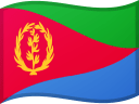
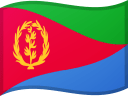
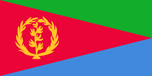
Eritrea Flag

Eritrea's national flag was established on December 5, 1995. It has a basic layout and colors inspired by the Eritrean People's Liberation Front banner, as well as an emblem featuring a wreath and an upright olive branch adopted from the flag used from 1952 to 1962.
The flag's green tint signifies the country's agriculture and livestock industries, blue represents the abundance of the sea, and red represents the blood spent in the fight for Eritrean independence. The wreath's 30 leaves represent the 30 years spent fighting for independence.
Eritrea flag downloads
- completely free for commercial and non-commercial use (public domain)
- based on vector file from Wikipedia Commons
- PNG or WebP format (lossless compression)
- Right click on the links (save link as)
| Width | Height | PNG | WebP |
|---|---|---|---|
| 20px | 10px | ~0.1 KB | ~0.1 KB |
| 40px | 20px | ~0.4 KB | ~0.1 KB |
| 80px | 40px | ~0.7 KB | ~0.1 KB |
| 160px | 80px | ~2.6 KB | ~0.6 KB |
| Width | Height | PNG | WebP |
|---|---|---|---|
| 16px | 12px | ~0.1 KB | ~0.1 KB |
| 40px | 30px | ~0.4 KB | ~0.1 KB |
| 80px | 60px | ~0.8 KB | ~0.1 KB |
| 128px | 96px | ~2.5 KB | ~0.6 KB |
- completely free for commercial and non-commercial use (public domain)
- based on vector file from Wikipedia Commons
- PNG, WebP (lossless compression) or JPEG format (100% quality)
- Right click on the links (save link as)
| Width | Height | PNG | WebP | JPEG |
|---|---|---|---|---|
| 2560px | 1280px | ~2.6 KB | ~0.6 KB | ~34.9 KB |
| 1280px | 640px | ~0.7 KB | ~0.1 KB | ~13.0 KB |
| 640px | 320px | ~0.4 KB | ~0.1 KB | ~5.6 KB |
| 320px | 160px | ~0.2 KB | ~0.1 KB | ~2.8 KB |
| 160px | 80px | ~0.1 KB | ~0.1 KB | ~1.5 KB |
| 80px | 40px | ~0.1 KB | ~0.1 KB | ~0.9 KB |
| 40px | 20px | ~0.1 KB | ~0.1 KB | ~0.6 KB |
| 20px | 10px | ~0.1 KB | ~0.1 KB | ~0.4 KB |
- completely free for commercial and non-commercial use (public domain)
- based on vector file from Wikipedia Commons
- SVG, PDF (Adobe Acrobat), AI (Adobe Ilustrator) or EPS format
- Right click on the links (save link as)
| Format | SVG | AI | EPS | |
|---|---|---|---|---|
| Vector download | ~0.3 KB | ~12.5 KB | ~29.7 KB | ~1533.8 KB |
Country information
Eritrea is a country located in the Horn of Africa, bordered by Sudan to the west, Etiopia to the south, and Gibuti to the southeast. It is a small country with a land area of about 45,000 square miles, and it is home to over 6.5 million people, making it the 138th most populous country in the world.
Eritrea has a diverse and multicultural society, with people of Afar, Tigre, and other African descent living in the country. The official languages are Tigrinya and Arabic, and the country has a predominantly Muslim population.
Eritrea has a varied and unique landscape, ranging from mountains to deserts to coastlines. The climate is hot and dry, with temperatures reaching over 100 degrees Fahrenheit in the summer. The country is known for its beautiful natural scenery and history, and it is a popular tourist destination.
Eritrea has a presidential system of government and is a republic. It is a member of the African Union, the Arab League, and the United Nations, and it has a strong relationship with other countries in the region.
Eritrea has a strong and diversified economy, with a wide range of industries including agriculture, manufacturing, and tourism. It is a major exporter of livestock, hides, and skins.
| Independent | Yes |
| Country codes | ER, ERI (ISO 3166-1) |
| Official name | State of Eritrea |
| Official languages | Tigrinya, Beja, Tigre, Kunama, Saho, Bilen, Nara, Afar |
| Religion | 62.9% Christianity, 36.6% Islam, 0.5% Others / None |
| Capital city | Asmara |
| Continente | Africa |
| Time zone | UTC+3 (EAT) • Summer (DST) • UTC+3 |
| Member of | Delle Nazioni Unite |
| Unione Africana | |
| Population | 3,670,558 (2023) |
| Population density | 35 per Km2 (91 people per mi2) |
| Urban Population | 63.3 % of the population is urban (2,246,038 people in 2020) |
| Migrants (net) | -39,858 |
| Median age | 19.2 years |
| Total area | The total land area is 101,000 Km2 (38,996 sq. miles) |
| Highest point | Emba Soira (3 018 m, 9 902 ft) |
| Lowest point | Lake Kulul (-75 m, -246 ft) |
| GDP per capita | $ 643 (World Bank, 2021) |
| Currency | Eritrean nakfa (Nfk, ERN) |
| Calling code | +291 |
| Internet TLD | .er (click here to find and register domain name) |
| Country Wikipedia Page | Eritrea Wikipedia Page |
Main Cities by Population in Eritrea
| # | CITY NAME | POPULATION |
|---|---|---|
| 1 | Asmara | 563,930 |
| 2 | Keren | 74,800 |
| 3 | Massawa | 23,100 |
| 4 | Assab | 21,300 |
| 5 | Mendefera | 17,781 |
| 6 | Barentu | 15,891 |
